Fiordland National Park – 1
We are staying in a bach about 1 mile from Lake Manipouri. Our views here remind us of the time we spent in Grand Teton National Park. Lake Manipouri is one of a few very deep glacial lakes that border the fiords in this park. This lake is about 1,500 feet deep.
 |
| Keplar Mountain Cottage View |
 |
| Lake Manapouri |
Doubtful Sound
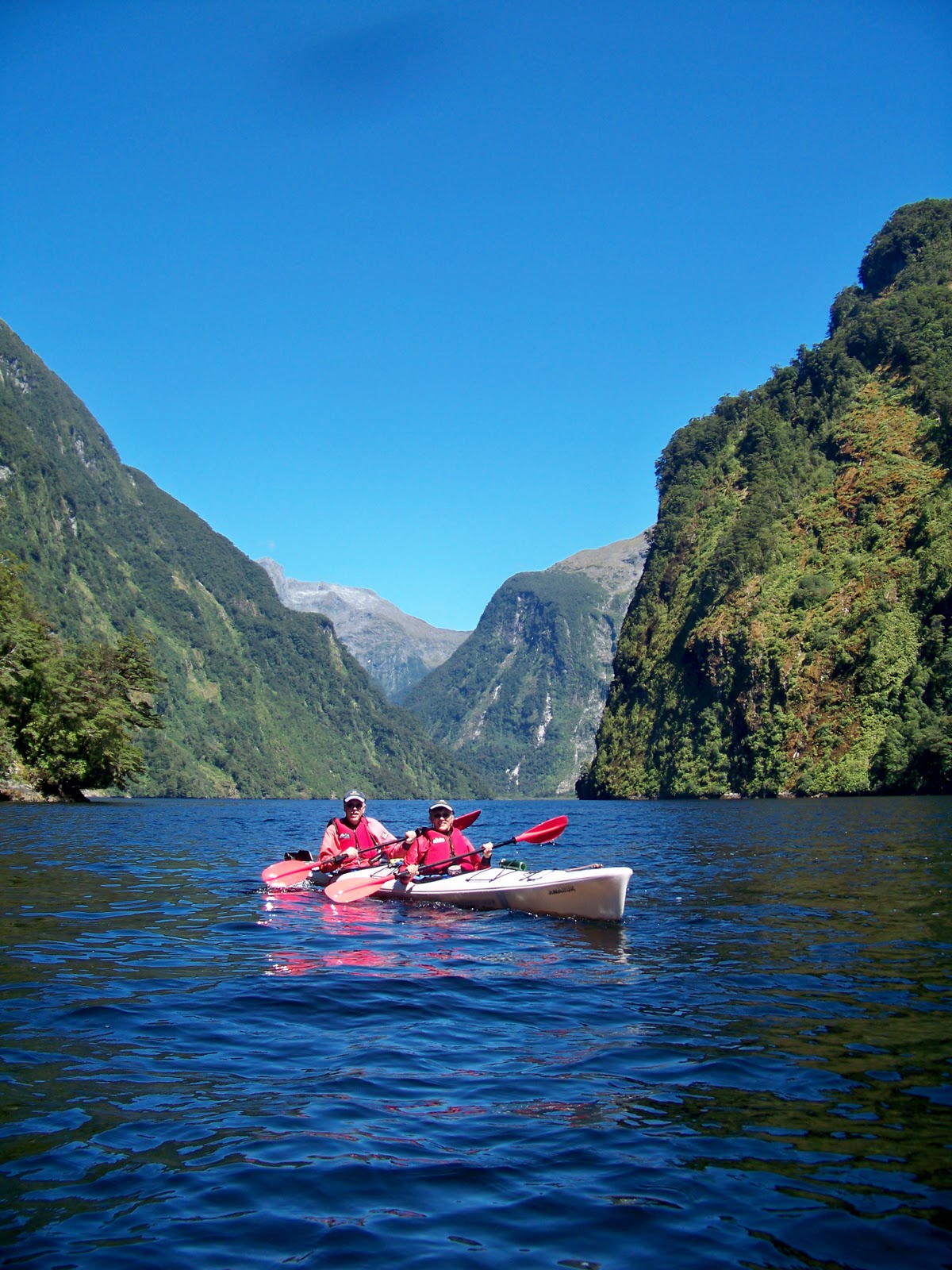
The day of our long awaited kayak trip on Doubtful Sound arrived. Our tour started at 7:30 a.m. with 7 other kayakers and our guide. After an 18-mile boat ride across Lake Manipouri to West Arm, we boarded a bus and traveled 13 miles across the Wilmot Pass to Deep Cove, at sea level.
 |
| Wilmot Pass looking at Doubtful Sound |
We had a warm and sunny day for our trip. We paddled in the fjords for a total of 5 hours with a stop for lunch. The serenity of paddling in the fjord was amazing. Doubtful Sounds receives an average of 26 feet of rain per year, so you can imagine the various shades of green surrounding you. The land around you shoots straight up from the waters edge. We paddled under Commander Peak, which rises 4,000 feet.

 |
| Commander Peak |
Rainforests cling to the towering mountains and many waterfalls tumble down their sides. There is evidence of many slides where the rainforest gave way and tumbled down the steep sides. Bare rock and later colorful mosses replace the trees and begin the cycle once more.
 |
| Mosses below Commander Peak |
 |
| B and G 'yakin' |
We returned to Lake Manipouri about 5:30 p.m. from a day we will long remember.
More birds
The well-loved New Zealand Pigeon, is a common but protected endemic bird.
 |
| New Zealand Pigeons |
The takahe was once thought to be extinct, until a small population was found in Fiordland in 1948. One hundred and seventy birds remain in Fiordland. This flightless bird is about 2 feet in length. Takahe’s body weight increased and became flightless as they evolved, because they had no need to escape predators or fly to obtain food. The takahe in this picture lives in captivity in a protective wildlife park.
 |
| takahe |
For you Lord of the Rings fans
Fiordland National Park was the location for many scenes used in the Lord of the Rings Trilogy. For fun we took to the back roads, to combine a walk around Mavora Lakes with a search for a few movie location sites using our handheld GPS. You need the coordinates, as there are no signs in this remote area. We enjoyed narrowing down the exact location and finding a site that appeared familiar to us.
Parts of the Silverlode and Anduin River are actually the south end of South Mavora Lake (near the outlet of the Mararoa River).
 |
| South Mavora Lake |
Nen Hithoel
In Nen Hithoel, Merry and Pippen hid from the Orcs and the large tree shielded Frodo from the Uruk-hai at the end of the The Fellowship of the Ring (S45 degrees 16.024’- E168 degrees 10.500’). This site is in the woods beside North Mavora Lake.
 |
| Frodo's Fangorn Forest Tree |
North Mavora lakeside was also the site where the campfire was lit prior to the breaking of the fellowship. It also marks the spot where Sam kept his promise to Frodo and nearly drowned trying to swim to Frodo as they departed for Mordor. (S45 degrees 15.993’ – E168 degrees 10.410’)
 |
| North Mavora lakeside |
Fangorn Forest
As we drove to Mavora Lakes, we came across the edge of Fangorn Forest, where Eomer and the Riders of Rohan burnt the remains of the dead orcs after their battle. Merry and Pippen crawled from the orcs into the forest to escape. It is also here, where Gandolf the White whistled for Shadowfax across the field. (S45 degrees 19.968’ – E168 degrees 10.404’)
 |
| B at Fangorn Forest edge |
No comments:
Post a Comment